Two important correlations:
1.) the zone of slower seismic wave velocity corresponded to a weak pliable zone. The asthenosphere which had been postulated earlier to aid in defining isostacy was now the fluidized zone for moving continents.
2.) That the top most layer of the mantle was strong enough to float above the asthenosphere and carry crust on its back. This means that the crust moves along as a part of the lithosphere and does not slide over other parts of the crust.
This also provided a stage for the next needed answer.
If the sea floor is spreading it is growing and thus the oceans should continue to expand forever growing a bigger planet. (Not to plausible!) The moving plates provide the mechanism for a "subduction" zone that is responsible for destroying older crust in an orderly fashion.
Creation of new crust and destruction of old crust are thus in balance.
(Supported by the Benioff zone results.)
The lithosphere must be solid enough not to buckle, and strong enough to hold the continents on its back. But is also must have a small degree of flexibility in order to bend slightly at its margins. If not it could not subduct.
As mentioned in chapter 2: (3 kinds of possible margins)
1.) Divergent Margins
2.) Convergent Margins
3.) Transform Margins
These are spreading centers and as such are the location of newly formed crust. Magnetic dating shows us that the last magnetic pole change happened about 730,000 years ago. (Date at the ridge.) Along the edge of the expanding plates the oldest date is about 175,000,000 years ago. The magnetic patterns show us that he plates expand in each direction at the same rate, but they do not provide us with a standard rate.
Observing the various plate motions and measuring them provides us with another insight. Those plates with large land masses move slower than those with mainly ocean crust. Another reason that plates move at different relative speeds is because they are on the surface of a sphere.
Remember the idea of the Coriolis effect, different parts of the sphere move at different velocities. The plates are also effected by the rotation of the earth.
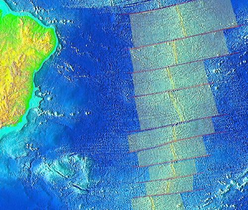
This is a bit hard to understand at first. It shows that the plates separate based on a "spreading axis" (yellowish in diagram above), and the spreading axis may or may not be aligned with the spinning axis of the earth. The spreading axis defines the center of spread, but it is further changed by the polar rotation of the planet.
As you might expect, those places that are spreading near the equator will spread further than those near a pole. (Higher earths velocity near the equator. (Remember the Coriolis effect.)
Each spreading axis lines in the direction of the spreading pole. Each offset will align to the rotating axis of the earth. and hence line up with lines of latitude.
First Correlation
Areas where the spreading is rapid mean two things are happening:
1.) the magma chamber must be shallow
2.) and large
Hence the central ridge will grow rapidly and high.
A slow spreading chamber can be lower in the ground and cooler.
Hence the central ridge is wider and lower.
Second Correlation
Since there is a lot of heat at the spreading center, those areas near it will also become thermally expanded. The lithosphere will swell with the heat and thus be higher near the ridge. As the lithosphere continues to spread it cools as it gets further from the center and hence contracts. After about 100 million years it reaches thermo- equilibrium and the sea floor has about the same depth form then on.
| NEXT | TOC | PREV |