Porosity
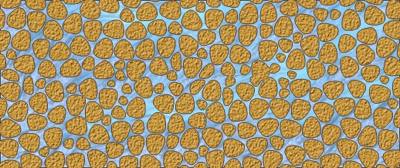
Porosity: is the percentage of free area between the particles of the regolith. It is a volume measurement. It does not take into account the shape or architecture of the volume.
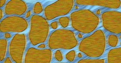
Permeability: is a measure of how easy a solid allows a liquid to flow through it. It is a flow measurement. A rock with poor porosity is likely to have low permeability.
A rock may have high porosity, but poor permeability. This is because it may have a very fine particle size, but may be highly compressed with little free channelling.
The size of the pores and whether they are continuous or exist only in separated bodies will affect the permeability.
The upper rock example has similar porosity to the lower. The lower rock has much better permeability as the water has a straighter path and it flows through larger channels.
The upper rock has narrow channels and a more contorted path.
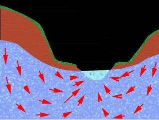
Percolation is the term used to describe the movement of water in the saturated zone. Water moves from areas where the water is high to areas where to is low. (Gravity at work.)
Water may actually travel in an upward direction to enter a lake from the bottom. This can happen if the water is under sufficient pressure, as it will travel to an area of less pressure.
Since the water table is higher at some points, this causes pressure on water lower in the strata . If it can find a path back to a lower pressure area (say the bottom of a lake or stream) then it may rise and empty into the external body of water.
Recharge areas are those where water enters the ground water cycle. They are areas that collect rain or snow and begin transferring down.
Discharge areas are areas where the water is returned above the ground water in streams, lakes or the ocean.
Recharge areas are many times larger than discharge areas or there would eventually be no ground water left.
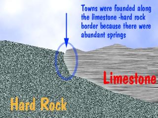
Springs and Wells
Human use of groundwater is usually obtained via a Spring or a Well. A spring is the natural flow of groundwater out of a surface. It may be a lateral flow or even an upward flow.
Springs are usually created when permeable rock meets impermeable rock. This junction is called an aquiclude.
| NEXT | TOC | PREV |